Spatial Modelling of Vehicular Emissions and Air Quality
ON GOING
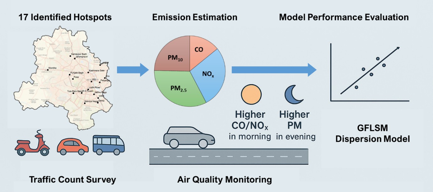
This domain tackles urban environmental challenges through the precise spatial disaggregation of vehicular emissions. Utilising GIS and road density-based modelling, the research maps high-resolution pollution distribution across megacities. These insights empower city planners to design targeted mitigation strategies to improve urban air quality and public health.
This vital research trajectory addresses the urgent need for high-resolution environmental modelling by focusing on the complex spatial disaggregation of road traffic emissions within densely populated megacities. The foundational work directly tackles the methodological challenges of translating macro-level emission inventories into actionable, micro-level environmental data. A central theme of this research is the critical evaluation of various allocation factors—such as population density, urban sprawl, and traffic volume distribution—and their consequential impact on how vehicular pollution is mapped across a city grid. The studies demonstrate that relying on broad or inappropriate disaggregation metrics can lead to significant misrepresentations of localised air quality, thereby misguiding municipal environmental policies. By rigorously refining these allocation algorithms, the researchers ensure that emission models accurately reflect the true spatial distribution of pollutants, highlighting the specific neighbourhoods and corridors that bear the heaviest environmental burdens from daily urban traffic.
To achieve this granular level of emission mapping, the research group heavily leverages advanced Geographic Information Systems (GIS) to construct robust, road density-based models. These sophisticated spatial frameworks seamlessly integrate vast datasets encompassing vehicular flow, engine types, and intricate road network geometries. By anchoring the spatial allocation of emissions directly to the physical density and layout of the road infrastructure, the models provide a much more realistic representation of where exhaust plumes are concentrated. This GIS-centric approach allows the researchers to pinpoint specific urban hotspots where poor air quality poses the greatest risk to public health. The creation of such detailed, visually comprehensive emission inventories serves as a vital diagnostic tool for environmental engineers and city planners. Consequently, it moves the discourse from general estimations of city-wide pollution to exact, street-level analyses, enabling a far deeper understanding of how the built environment and traffic engineering directly dictate the localised atmospheric conditions.
The ultimate objective of this rigorous spatial modelling is to provide a solid, evidence-based foundation for designing effective and targeted mitigation strategies. Because the research clearly identifies the specific mechanisms through which road density dictates vehicular emission hotspots, it empowers policymakers to move beyond blanket, city-wide regulations that are often economically disruptive and difficult to enforce. Instead, authorities can utilise these models to deploy highly localised interventions, such as implementing low-emission zones, optimising traffic light synchronisation in heavily congested grid sectors, or strategically routing heavy freight traffic away from vulnerable residential areas. Furthermore, this research plays a crucial role in long-term urban planning, informing decisions regarding where to develop new public transit corridors or establish green buffers to counteract traffic pollution. By translating complex spatial emission data into clear policy directives, this body of work represents a crucial step towards cultivating healthier, more sustainable urban environments in rapidly expanding metropolitan regions across the developing world.
Publications
Impact of allocation factors on spatial disaggregation of road traffic emissions in Megacity Delhi
Swarnkar, A., Gurjar, B. R., & Suman, H. K. (2025a). Impact of allocation factors on spatial disaggregation of road traffic emissions in Megacity Delhi. Air Quality, Atmosphere & Health, 18(5), 1305–1325. https://doi.org/10.1007/s11869-025-01706-7
Road Density-Based Model for Spatial Allocation of Vehicular Emissions
Swarnkar, A., Gurjar, B. R., & Suman, H. K. (2025b). Road Density-Based Model for Spatial Allocation of Vehicular Emissions. In V. Srinivasan, U. Jain, M. V. L. R. Anjaneyulu, & M. Parida (Eds.), Recent Advancements in Sustainable and Safe Transportation Infrastructure—Vol. 1 (Vol. 621, pp. 405–416). Springer Nature Singapore. https://doi.org/10.1007/978-981-96-1984-9_33
People Working